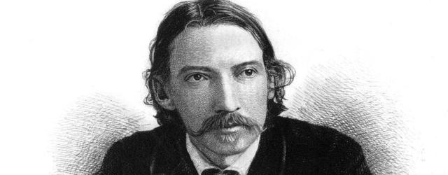
Robert Louis Stevenson 1850 - 1894
In 1878 Robert Louis Stevenson hiked from Monastier-sur-Gazeille, near Le Puy en Velay, across the Cévennes Mountains to St Jean du Gard, a distance of 225 km with a donkey he called "Modestine". His adventure took him across the Velay, the Gévaudan and the Cévennes, and in 1879 he published an account of his journey entitled "Travels with a Donkey in the Cévennes". This was indeed a remote and mountainous area, and the latter parts of the hike took him through the land of the Camisards, an area ravaged by 100 years of war between the local Protestants and their Catholic rulers.
In 1994 the trail was adopted by the Fédération Française de la Randonnée Pédestre and it became the GR70 that we walk today. The walk has much less road walking than its original incarnation, but still links up the villages and towns that Stevenson visited.
You have to walk the Stevenson trail to appreciate what he achieved in 1878. He had virtually nothing to help him; no accurate maps, no modern equipment (he even had to design and have made a crude "bivvybag" for sleeping outdoors) and was walking through a remote area where there was natural suspicion of outsiders. His only means of assistance and company was the donkey "Modestine". But the legacy he left behind is remarkable. "Stevenson" is an industry today, proving a huge boost to the local economy through maps, gear, communications, hotels, restaurants, bag transfer companies etc. In the whole two weeks you hardly pass an hour with out the mention of "Stevenson" at least several times.
Although the title of his book was "Travels with a Donkey in the Cévennes", the Cévennes region is not reached until about half way along the trail, at Mont Lozère.
The trail passes through three modern départements; the Haute-Loire, until just before Langogne, Lozère for most of the rest of the trail, and Gard for the last few kilometers. The Haute-Loire belongs to the Auvergne region, while Lozère and Gard form part of Languedoc-Rousillon. |
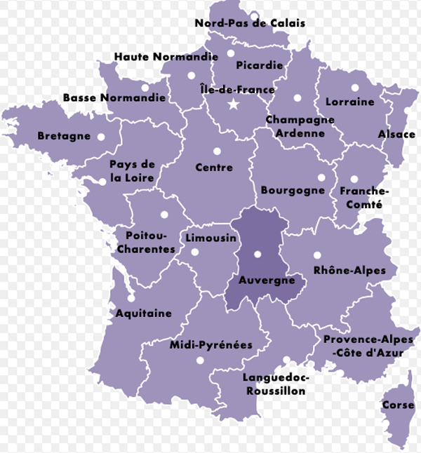
The Auvergne consists of 4 departments or counties
- The Allier in the north - mostly an area of plains and valleys with small hills, with the cities of Moulins, Montluçon and Vichy
- The Puy de Dome in the middle - largely mountainous, but with a large fertile agricultural plain, the Limagne, in the middle, to the east of Clermont Ferrand.
- The Haute Loire in the south east, the driest and sunniest part of the Auvergne, a lot of it at an altitude of over 800 metres. Virtually the whole department is hilly or mountainous, and a lot is forested. The northern area is centered round the market town of Brioude, with its magnificent Romanesque basilica, the largest in the region. South of Brioude lies the "Haut Allier", a region with deep valleys, a generally warm and sunny climate and a definite flavour of the south of France. The southern part of the department is known as "le Velay"; its capital, Le Puy en Velay, was a major pilgrimage centre in the middle ages, a starting point on the route to Santiago de Compostella, and to this day the city's cathedral and St Michael's chapel remain remarkable examples of early mediaeval architecture.
- The Cantal, in the south west, is the highest of the four departments, a lot of it over 1000m altitude. The department boasts two main centres, the bustling market town of Aurillac, the department's capital, to the west of the high mountains, and Saint Flour, an ancient town perched dramatically at the top of a volcanic outcrop in the east of the department, and visible from the motorway. The centre of the Cantal is dominated by the Plomb du Cantal and the peaks around it, a massive volcanic cluster marking the heart of the Massif Central mountains.
|
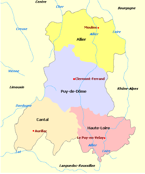
The Auvergne
Languedoc Roussillon has five departments
| |
Lozère, |
|
| |
Gard, |
|
| |
Hérault, |
|
| |
Aude |
|
| |
Pyrénées-Orientales |
|
| All are relatively poor when compared to France's other departments, and have forged five diverse cultures and economies. The cool, empty highlands of Lozère are a world away from the hot and exotic Catalan region of the Pyrenees-Orientals, with its superb beaches with views of the snow-capped Pyrénées in the distance. Hérault, Languedoc's most populous department, is also its fastest-growing, with thousands moving to Montpellier (Languedoc's capital) every month. The Aude, perhaps the region's most gentle department, hosts the magnificent Canal du Midi as well as La Cité at Carcassonne. The Gard has a more Provençal feel with the Rhône river on its eastern border, the Cévennes mountains to the north, and the marshlands of the Camargue to the south. |
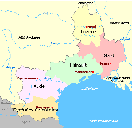
Languedoc Roussillon
The geography of Lozère is complicated, covering four mountain ranges.
- Aubrac, in the north-west, a basalt plateau that rises between 1,000 and 1,450 m (3,280 and 4,760 ft), with a cold humid climate influenced by the Atlantic.
- Margeride, in the north and north-east of the department, comprises mountains which are formed of granite, and have peaks between 1,000 and 1,550 m (3,280 and 5,090 ft). The climate here is also cold, but dryer than in Aubrac, with less snow.
- Causses are a series of very dry limestone plateaus in the south-west,
- Cévennes in the south-east , which include the highest point in the department, the granite Mont Lozère at 1,699 m (5,574 ft).
The department also contains numerous rivers, above and below ground, including the Tarn, whose source is on Mont Lozère, and which flows through the Gorges du Tarn in the Causses. |
The Stevenson Trail route
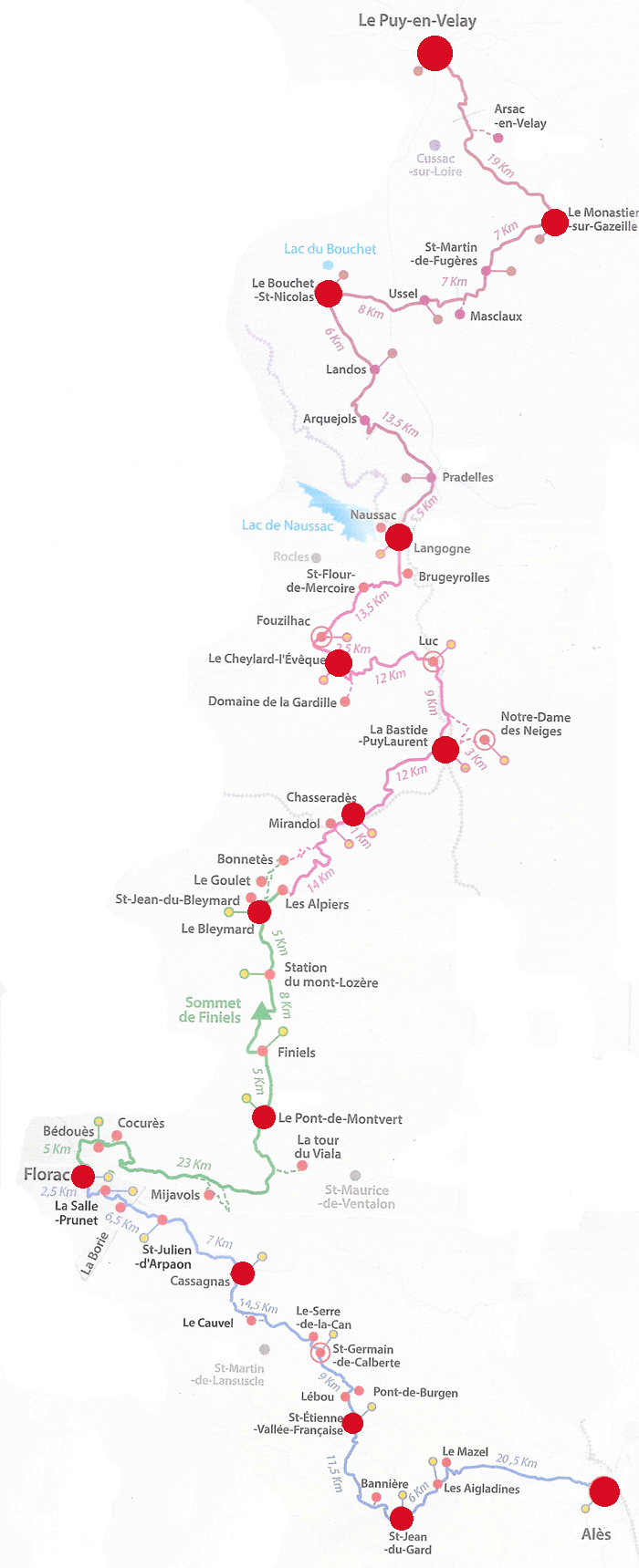
Source: Free brochure published by "Association Sur Le Chemin de Robert Louis Stephenson, Le Village,
48220 Le Pont-de-Montvert, France" website https://www.chemin-stevenson.org
Source: M. J. Piper
The Schedule
| Hotels on a demi-pension basis and baggage transfer by "Transbagages" (Tel: 04 66 65 27 25) was organised in advance for me by |
La Pelerine
Place Limozin,
43170 Sauges
+33 (0) 4 71 74 47 40
contact@lapelerine.com
www.lapelerine.com
| |
Date |
From |
To |
Moving Time
Hrs/Mins |
Km |
Cum |
| |
Mon 7 Sep |
Travel to Le Puy en Velay
Eurostar ETD Ashford 07-55 hrs ETA Lyon Part Dieu 13-00 hrs (£89.50)
ETD Lyon Part Dieu 14-54 hrs ETA St Etienne 15-40 hrs
ETD St Etienne 15-53 hrs ETA Le Puy en Velay 17-20 hrs (€ 18.60)
Hotel Bristol, Le Puy en Velay
|
|
|
|
| |
Tues 8 Sep |
Sightseeing in Le Puy en Velay
Hotel Bristol, Le Puy en Velay
|
|
|
|
| 1 |
Wed 9 Sep |
Le Puy en Velay |
Le Monastier sur Gazeille
Auberge Les Acacias |
4-39 |
21.8 |
|
| 2 |
Thur 10 Sep |
Le Monastier sur Gazeille |
Le Bouchet St Nicolas
Chambres d'Hotes L'Houstaou |
5-21 |
25 |
46.8 |
| 3 |
Fri 11 Sep |
Le Bouchet St Nicolas |
Langogne
Hotel de la Poste |
6-03 |
28.56 |
75.36 |
| 4 |
Sat 12 Sep |
Langogne |
Cheylard l'Évêque
Le Refuge du Moure |
3-50 |
17.6 |
92.96 |
| 5 |
Sun 13 Sep |
Cheylard l'Évêque |
La Bastide PuyLaurent
Hotel La Grande Halte |
4-40 |
22.57 |
115.53 |
| 6 |
Mon 14 Sep |
Side Trip to N.D. de Neiges |
|
1-41 |
7.73 |
123.26 |
| 6 |
Mon 14 Sep |
La Bastide PuyLaurent |
Chasseradès
Hotel Des Sources |
2-30 |
12.1 |
135.36 |
| 7 |
Tues 15 Sep |
Chasseradès |
Le Bleymard
Hotel La Remise |
3-36 |
17.35 |
152.77 |
| 8 |
Wed 16 Sep |
Le Bleymard |
Pont de Montvert
Auberges Des Cévennes |
4-59 |
22.8 |
175.57 |
| 9 |
Thurs 17 Sep |
Pont de Montvert |
Florac
Hotel Des Gorges Du Tarn |
5-11 |
26.6 |
202.11 |
| 10 |
Fri 18 Sep |
Florac |
Le Cauvel
Le Château de Cauvel |
5-34 |
25.8 |
227.91 |
| 11 |
Sat 19 Sep |
Cassagnas |
St Étienne Vallée Française
Château de Cambiaire |
4-16 |
20.44 |
248.35 |
| 12 |
Sun 20 Sep |
St Étienne Vallée Française |
St Jean du Gard
Hotel Oronge |
3-01 |
14.64 |
262.99 |
| 13 |
Mon 21 Sep |
ETD St Jean du Gard 06-40 hrs ETA Alès (by Bus)(€ 1)
ETD Alès 07-57 hrs ETA Nîmes 08-37 hrs (by Train) (€ 9-90)
ETD Nîmes 09-26 hrs ETA Lyon Part Dieu 10-50 hrs (TGV € 60)
ETD Lyon Part Dieu 17-25 hrs ETA Ashford 21-34 hrs (Eurostar £74.50)
|
|
|
|
| |
|
|
|
|
|
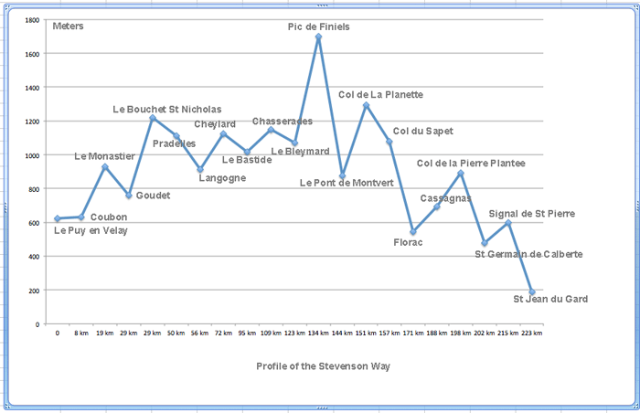
GPS Statistics
| |
|
Distance |
Time |
Elevation in meters |
Pace |
| Day |
To |
Km |
Elapsed
Hrs-Mins |
Moving
Hrs-Mins |
Gain |
Loss |
Max |
Min |
Average km/hr |
| 1 |
Monastier sur Gazeille |
21.8 |
5-45 |
4-39 |
587 |
328 |
982 |
627 |
4.68 |
| 2 |
Le Bouchet St Nicolas |
25.01 |
6-46 |
5-21 |
800 |
500 |
1,224 |
765 |
4.67 |
| 3 |
Langogne |
28.56 |
7-10 |
6-03 |
390 |
703 |
1,238 |
901 |
4.71 |
| 4 |
Cheylard l'Évêque |
17.6 |
4-29 |
3-50 |
416 |
214 |
1,241 |
910 |
4.59 |
| 5 |
La Bastide PuyLaurent |
22.57 |
5-25 |
4-40 |
495 |
601 |
1,247 |
972 |
4.83 |
| 6 |
Notre Dame de Neiges |
7.73 |
1-45 |
1-41 |
165 |
165 |
1,109 |
1,020 |
4.57 |
| 6 |
Chasserades |
12.1 |
2-45 |
2-30 |
437 |
320 |
1,312 |
1,020 |
4.84 |
| 7 |
Le Bleymard |
17.35 |
4-00 |
3-36 |
553 |
643 |
1,413 |
1,073 |
4.81 |
| 8 |
Pont du Montvert |
22.8 |
6-21 |
4-59 |
691 |
880 |
1,698 |
876 |
4.56 |
| 9 |
Florac |
26.6 |
7-16 |
5-11 |
867 |
1,198 |
1,415 |
542 |
5.12 (?) |
| 10 |
Le Cauvel |
25.8 |
6-43 |
5-34 |
810 |
595 |
961 |
548 |
4.63 |
| 11 |
St Étienne Vallée Française |
20.44 |
5-15 |
4-16 |
484 |
963 |
973 |
249 |
4.79 |
| 12 |
St Jean du Gard |
14.64 |
4-10 |
3-01 |
485 |
592 |
605 |
185 |
4.85 |
| |
Total |
263 |
|
|
7,180 |
7,704 |
|
|
|
|